How Yellowstone Is Monitored: Earthquakes, Ground Motion, Alerts
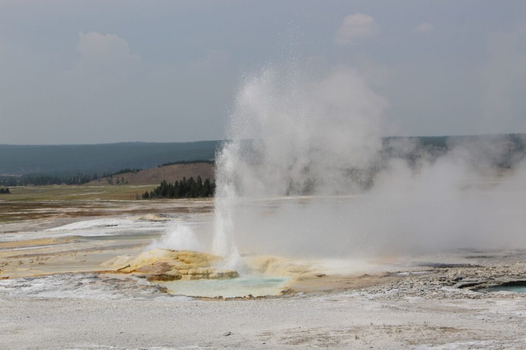
The Yellowstone Volcano Observatory (YVO) monitors Yellowstone with seismometers, GPS stations and other instruments, and publishes a monthly update with the current alert level. As of the November 2, 2026 update, Yellowstone’s Volcano Alert Level was NORMAL and its Aviation Color Code was GREEN. YVO reported 66 located earthquakes in October 2026, the largest a magnitude 2.0, and no significant uplift or subsidence of the caldera over the past several months.
What is the Yellowstone Volcano Observatory?
YVO is one of the five USGS volcano observatories that monitor US volcanoes. It is a consortium of nine member agencies: the USGS, Yellowstone National Park, the University of Utah, the University of Wyoming, Montana State University, the EarthScope Consortium, the Wyoming State Geological Survey, the Montana Bureau of Mines and Geology and the Idaho Geological Survey. The November 2026 update lists Michael Poland of the USGS as scientist-in-charge.
The University of Utah Seismograph Stations operates the Yellowstone Seismic Network and locates the earthquakes that YVO reports. For ground motion, USGS calls GPS the backbone of YVO’s deformation monitoring, supplemented by strainmeters and tiltmeters. USGS lists 16 continuously recording GPS stations inside Yellowstone National Park and many more in the surrounding region. The USGS Yellowstone volcano monitoring page describes the networks.
What is the current alert level at Yellowstone?
Yellowstone was at NORMAL/GREEN in the November 2, 2026 monthly update, the same level reported on October 1, 2026. In USGS terms, Normal means a volcano is in a typical background, noneruptive state. Any change of level would come with a Volcano Activity Notice, separate from the monthly report. The volcano alert levels guide explains the full scale, and our list of US volcanoes with elevated alert levels shows which volcanoes USGS currently rates above Normal.
How many earthquakes does Yellowstone have?
Yellowstone has about 1,500 to 2,500 located earthquakes in a typical year, according to USGS. Most are too small to feel. In 2024, the University of Utah Seismograph Stations located 1,173 earthquakes in the Yellowstone region, and 1,112 of them were smaller than magnitude 2. USGS noted that the 2024 total was not particularly unusual, because counts of about 700 were recorded in 2011 and 2012.
Many Yellowstone earthquakes come in swarms, groups of small earthquakes close together in place and time. YVO’s two most recent monthly reports:
| Month | Located earthquakes | Largest | Swarms |
|---|---|---|---|
| September 2026 | 77 | M3.4, about 20 miles northeast of Moran, Wyoming (September 6) | One swarm of 24 earthquakes, magnitudes -0.1 to 2.8, about 7 miles north-northwest of West Yellowstone, Montana (September 8) |
| October 2026 | 66 | M2.0, about 15 miles south of West Thumb (October 4) | None identified |
YVO described earthquake activity in both months as background levels. Our pages for earthquakes in Wyoming and earthquakes in Montana list recent USGS data for the area. For what the numbers mean, see earthquake magnitude explained.
How does YVO measure ground movement?
GPS stations record small changes in the height and position of the ground. YVO uses them to report whether the caldera floor and the area north of the caldera rim are rising, sinking or holding steady.
In the November 2, 2026 update, YVO said continuous GPS data show little net deformation of the caldera or north caldera regions over the past several months. YVO added that subtle variations are probably caused by seasonal changes, especially in groundwater. Longer trends appear in YVO’s annual reports. According to the 2024 report, GPS stations inside the caldera subsided by about 1 inch (2 to 3 centimeters) that year, continuing a pattern that began around 2015 to 2016.
Why do hydrothermal explosions matter?
USGS says hydrothermal explosions are the most likely of Yellowstone’s volcano-related hazards. In one, a hot spring or pool throws boiling water, steam, mud and rock into the air. Biscuit Basin, in the Upper Geyser Basin not far from Old Faithful, has had several recent ones:
- July 23, 2024: a hydrothermal explosion at Black Diamond Pool.
- June 13, 2026: a hydrothermal explosion that left a small pool of hot water formed by collapse.
- September 27, 2026: that new pool threw boiling water, steam, mud and rocks at least 100 feet (30 meters) into the air, the first significant explosion from it. A nearby seismic, acoustic and camera station recorded the event.
YVO also tracks geysers. Steamboat Geyser in Norris Geyser Basin had only one major eruption in 2026 through October. Giant Geyser in Upper Geyser Basin, the second tallest geyser in the park, erupted on October 5, 13 and 22.
What does USGS say about the chance of an eruption?
USGS says there is no evidence that a catastrophic eruption at Yellowstone is imminent. USGS approximates the yearly probability of another caldera-forming eruption at about 1 in 730,000, or 0.00014 percent. It compares that to the chance of an asteroid about 1 kilometer (0.6 mile) across hitting Earth. The figure is a calculation from Yellowstone’s eruption history, not a forecast.
USGS also rejects the idea that Yellowstone is overdue, calling it a misunderstanding of data and statistics. Its three caldera-forming eruptions happened about 2.08 million, 1.3 million and 631,000 years ago. The two intervals average about 730,000 years, and USGS says a future eruption would not have to follow any schedule. USGS adds that the rhyolite magma body under Yellowstone is only about 5 to 15 percent molten, so it is unclear whether there is enough eruptible magma to feed an eruption. Of all the possible scenarios, USGS calls another caldera-forming eruption by far the least likely.
On warning time, USGS says precursors such as strong earthquake swarms and rapid ground deformation typically appear days to weeks before an eruption. USGS also says most scientists think the buildup to a catastrophic eruption would be detectable for weeks and perhaps months to years. The USGS answer to whether Yellowstone is overdue for an eruption covers this in more detail.
How can you check Yellowstone yourself?
- Open the USGS Yellowstone volcano page for the current alert level and the latest monthly update.
- Read the update’s sections on seismicity, ground deformation and hydrothermal activity, and note the month it covers.
- Look at recent earthquakes near the park on our Wyoming and Montana pages or the USGS map.
- Subscribe to the USGS Volcano Notification Service to get Yellowstone notices by email.
- In the park, follow Yellowstone National Park rules and closures in thermal areas.
Bottom line
Yellowstone is watched continuously by a nine-agency observatory that reports earthquakes, ground motion and hydrothermal activity each month. As of November 2, 2026, it was at NORMAL/GREEN with background earthquake activity and little net ground motion. USGS puts the yearly chance of a caldera-forming eruption at about 1 in 730,000 and names hydrothermal explosions as the more likely hazard.
FAQ
Is Yellowstone overdue for an eruption?
No, according to USGS. Its large eruptions did not follow a schedule, and USGS says the overdue idea comes from a misunderstanding of data and statistics.
Does an earthquake swarm mean Yellowstone will erupt?
Swarms are common at Yellowstone. In September 2026, YVO reported a swarm of 24 small earthquakes and still described activity as background. USGS lists strong swarms together with rapid ground deformation among eruption precursors.
How often does YVO publish updates?
YVO publishes a monthly update, such as those of October 1 and November 2, 2026. A change in alert level is announced in a separate Volcano Activity Notice.
What is the most likely hazard at Yellowstone?
USGS says hydrothermal explosions are the most likely. Biscuit Basin had one on September 27, 2026 that threw debris at least 100 feet (30 meters) into the air.